
Core Objectives
Certification
Certifications are an important part of any technology. They let prospective employers know your students were motivated to begin and successfully complete a process to show their value and strengths. The STARS and SPACE Certifications provide this opportunity for the geospatial industry. Our focus on process as well as skills give your students the foundation for a great career and put students on a path to future certifications to continually redefine themselves.
We believe education is a journey from early education to retirement, so we strive to put students on a path with a strong foundation and knowledge of best practices. Start here and Start now. A career that can reward your students for a lifetime begins with us!
Mapped to Industry-Based Competency Models
Certification standards play a crucial role in the SPACE and STARS Certification. STARS was developed in 2003 with standards in mind and mapped to the Geospatial Technology Competency Model, the base for the DOL commissioned Geospatial Technology Apprenticeship model. As standards were developed STARS was a source for the new Geospatial Technology Competency Model released in 2010 and meets the core geospatial skills as well as addressing many of the non-geospatial skills. The new SPACE Certification follows these same traditions.
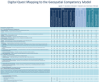
*Click Image to open the competency model. Once the image opens, click the image to enlarge.
Project Management
The Project Management Model (PMM) is the tool developed by Digital Quest to lead project managers through a set of steps, tasks, and techniques designed to help execute a thorough, successful geospatial project. The three phase process begins with Project Planning, flows into Project Implementation, and then concludes with Project Presentation. There is a defined flow in this model, and each part is critical for the entire model to be successful.
1. Project Planning
Project Planning involves successful completion of a list of tasks that will provide the foundation for the rest of the project. Each task is included to help ensure that any foreseeable obstacle that could pose a problem in the course of a project might be identified prior to Project Implementation.
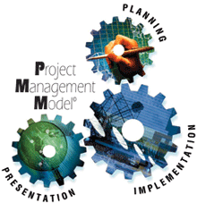
2. Project Implementation
In Project Planning, the problem was identified, an objective was established, a title was given, the geographic extent was determined, the stakeholders identified, the feasibility was studied, the functional requirements were listed, and a project design was created. Now that the groundwork has been set up for the project, it is time for the next step, Project Implementation.
3. Project Presentation
In Project Presentation, the findings for the entire project are packaged in order to communicate them to the stakeholders. Two popular presentation methods that are used in the Project Presentation phase of the Project Management Model are the written report and the oral presentation. Oftentimes though, combinations of both methods are used to communicate project findings to stakeholders. The project manager must keep in mind the intended audience that will be receiving the final report when constructing the report; whether it is in written or oral format.
Process Not Buttonology
We don't want students to learn to use a tool, we want them to learn to conduct thought geospatial provoking analysis. To learn a new technology and learn it well, users must find more than a simple cause and effect experience. Our curriculum is built to show different tools applied to various processes to maximize student understanding of a particular tool and how that tool can be combined with others to acheive goals. In addtion each title or lesson will feature a lesson problem, putting students in a goal oriented mindset rather than a bottonology mindset.
Application
A big question in a relatively new technology: Whose using geospatial technology and how? Our curriculum introduces students to geospatial technology through the eyes of the industry professionals that are pushing GIS to new areas. The aGIS series explores career paths and geospatial technology's role in enhancing those careers. The SPACE series features on community projects focused on a single topic area. The STARS series follows a certification path with each unit focused on different industries and topics. Throughout our entire product line students are exposed to:
Follow Us On:
 |
Share With Others:
|
Share With Others:


