
All About Geospatial Certification
- Certification Main
- SPACE Certification
- STARS Certification
- Beyond SPACE and STARS
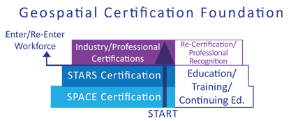
Certification Main
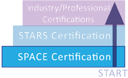
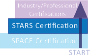
Certifications are an important part of any technology. They let prospective employers know your students were motivated to begin and successfully complete a process to show their value and strengths. The STARS and SPACE Certifications provide this opportunity for the geospatial industry. Our focus on process as well as skills give your students the foundation for a great career and put students on a path to future certifications to continually redefine themselves.
We believe education is a journey from early education to retirement, so we strive to put students on a path with a strong foundation and knowledge of best practices. Start here and Start now. A career that can reward your students for a lifetime begins with us!
Why You Need Certification...
Using our certifications gives your students a means to show potential employers a measured, standardized set of skills. This is a great asset for your program to attract potential students by providing a nationally competitive standard. Organizations can use this as a starting point or as a compliment to existing programs of study/certificate programs.
Certification vs. Certificate
Behind the Certification
Certifications are created with industry needs in mind. This leads to two crucial components for certification success: Standards Mapped to Industry Needs and Industry Backing. The STARS and SPACE certifications call upon a variety of sources to make sure they have the most complete requirements.
Certification standards play a crucial role in the SPACE and STARS Certification. STARS was developed in 2003 with standards in mind and mapped to the Geospatial Technology Competency Model, the base for the DOL commissioned Geospatial Technology Apprenticeship model. As standards were developed STARS was a source for the new Geospatial Technology Competency Model released in 2010 and meets the core geospatial skills as well as addressing many of the non-geospatial skills. The new SPACE Certification follows these same traditions.
On the industry side, STARS is sponsored by the Mississippi Enterprise for Technology (MsET), a Center of Excellence in Geospatial Technology at NASA's John C. Stennis Space Center, www.mset.org. MsET member companies consist of some of the best and brightest innovators in the geospatial technology field.
The SPACE Certification
The SPACE Certification is based on assessing an individual's user-level geospatial foundation. Geospatial technology is spread throughout many industries and high-growth job categories - becoming an essential skillset in many industries. The SPACE certification is a means to qualify student proficiency in geospatial skills and application of those skills to a particular career path. This certification bridges the gap between students looking towards a bright future in a particular career pathway and established professionals who need to add geospatial skills.
National, Industry Backed
The SPACE certifications are independently backed by the Enterprise for Geospatial Solutions (EIGS), Mississippi Enterprise for Technology (MsET), and the Magnolia Business Alliance (MBA). These organizations include some of the most innovative and influential companies in the geospatial industry.
Scalable and Modular Solutions
We believe in providing total solutions that allow room for expansion and are easily adapted to a school's unique needs. The curriculum mapped to this certification fits multiple career pathways. If your school is looking for a new technology that is cross curricular and relevant to much of the student body, the SPACE certification is available for up to eight different career pathways. If your school needs to enhance or expand an existing career pathway, SPACE can provide a relevant, unique, and measurable alternative.
Curriculum leading to the SPACE certification is also the same as the first 180 hrs of the STARS Certification. Students can gain valuable experience on the way to SPACE at which point schools have the option to offer an additional 180 hrs to reach STARS.
- Ag, Food, & Natural Resources
- Architecture, Engineering, & Construction (A/E/C)
- Green & Sustainability
- Health Science
- Homeland Security
- Law & Public Safety
- Marketing
- STEM
- Transportation & Logistics
180 Hrs
Pre-Requisites:
None
Certifying Body:
Enterprise for Innovative Geospatial Solutions (EIGS)
Additional Recognizing Organizations
Mississippi Enterprise for Technology (MsET); Magnolia Business Alliance (MBA)
Classroom Support Materials:
Each of our course are delivered as turn-key solution with Lesson Plans, PowerPoint, Presentation Notes, Assessments, and Technical Support. For more information on what teachers can expect Click Here
Two Components
1. Practical evaluation of map layouts created throughout Courseware.
2. Examination Assessment consisting of questions regarding career path and geospatial capabilities.
Courseware Titles*:
aGIS in Ag, Food, & Natural Resources
Introduction to GIS/RS Concepts
Intro to GIS Tools & Processes
Advanced Tools in GIS
Extended Tools in Surface Analysis
Basic to intermediate skills and processes essential to Geographic Information Systems, Remote Sensing, and GPS technologies. Process and Project Management essential to geospatial technologies and the larger information technology industry. Specific activities related to Ag, Food, & Natural Resources: Food, Products, & Processing Systems (Analyze poultry supply chain); Plant Systems (Monitoring Chemical usage on vegetation); Environmental Service Systems (Analyze natural barrier effectiveness in waste management); Animal Systems (Manage Virtual Fencing Technology; Natural Resource Systems (Identifying Suitable Wetland locations); Agribusiness (Mapping area businesses); Biotechnology (Crop management in multicrop field); Power, Structure, & Technical Systems (Assessing benefits of precision agriculture)
180 Hrs
Pre-Requisites:
None
Certifying Body:
Enterprise for Innovative Geospatial Solutions (EIGS)
Additional Recognizing Organizations
Mississippi Enterprise for Technology (MsET); Magnolia Business Alliance (MBA)
Classroom Support Materials:
Each of our course are delivered as turn-key solution with Lesson Plans, PowerPoint, Presentation Notes, Assessments, and Technical Support. For more information on what teachers can expect Click Here
Two Components
1. Practical evaluation of map layouts created throughout Courseware.
2. Examination Assessment consisting of questions regarding career path and geospatial capabilities.
Courseware Titles*:
GIS in Economic Development
Introduction to GIS/RS Concepts
Intro to GIS Tools & Processes
Advanced Tools in GIS
Extended Tools in 3D Visualization
Basic to intermediate skills and processes essential to Geographic Information Systems, Remote Sensing, and GPS technologies. Process and Project Management essential to geospatial technologies and the larger information technology industry. Specific activities related to Marketing: Analyzing Regional Indicators (Political Boundaries and LandUse, Landscape features, Population Demographics and Workforce, Transportation and Utility Infrastructure, Health/Safety/Education/Recreation); Site Suitability (Knock-out Constraints, Proximity to Constraints, Proximity to Opportunities, Suitability Analysis); Site Selection.
3D Analysis (Displaying 3D Data; Downloading and Processing 3D Data; Converting 2D Features to 3D; Creating a landscape; Aspect; Line of Sight; ArcGlobe; Animation).
180 Hrs
Pre-Requisites:
None
Certifying Body:
Enterprise for Innovative Geospatial Solutions (EIGS)
Additional Recognizing Organizations
Mississippi Enterprise for Technology (MsET); Magnolia Business Alliance (MBA)
Classroom Support Materials:
Each of our course are delivered as turn-key solution with Lesson Plans, PowerPoint, Presentation Notes, Assessments, and Technical Support. For more information on what teachers can expect Click Here
Two Components
1. Practical evaluation of map layouts created throughout Courseware.
2. Examination Assessment consisting of questions regarding career path and geospatial capabilities.
Courseware Titles*:
aGIS in STEM: Green & Sustainability Focus
Introduction to GIS/RS Concepts
Intro to GIS Tools & Processes
Advanced Tools in GIS
Extended Tools in Surface Analysis
Basic to intermediate skills and processes essential to Geographic Information Systems, Remote Sensing, and GPS technologies. Process and Project Management essential to geospatial technologies and the larger information technology industry. Specific activities related to Green & Sustainability: Alternative Energies (National and local assessment of alternative resources - solar, wind, and biomass); Biofuels (Analysis of biofuel resources); Conservation Biology/Habitat Management (creating habitat boundaries/analyzing urban green space); Renewable Resources (Analyzing specific biomass crop potential); Watershed Management (Identifying likely watershed funding sources); Wetland Management (Analyzing methods for wetland mitigation); Carbon Mapping (Visualizing carbon output over time))
180 Hrs
Pre-Requisites:
None
Certifying Body:
Enterprise for Innovative Geospatial Solutions (EIGS)
Additional Recognizing Organizations
Mississippi Enterprise for Technology (MsET); Magnolia Business Alliance (MBA)
Classroom Support Materials:
Each of our course are delivered as turn-key solution with Lesson Plans, PowerPoint, Presentation Notes, Assessments, and Technical Support. For more information on what teachers can expect Click Here
Two Components
1. Practical evaluation of map layouts created throughout Courseware.
2. Examination Assessment consisting of questions regarding career path and geospatial capabilities.
Courseware Titles*:
GIS in Mosquito Control
Introduction to GIS/RS Concepts
Intro to GIS Tools & Processes
Advanced Tools in GIS
Extended Tools in Surface Analysis
Basic to intermediate skills and processes essential to Geographic Information Systems, Remote Sensing, and GPS technologies. Process and Project Management essential to geospatial technologies and the larger information technology industry. Specific activities related to Health Science: Controlling Mosquito Population; Displaying Trap Location; Displaying Infected Pools in Control Zones; Tracking Mosquito-Borne Virus Infected Populations; Determining Trap Placement; Mosquito Host Spot Analysis and Animation
180 Hrs
Pre-Requisites:
None
Certifying Body:
Enterprise for Innovative Geospatial Solutions (EIGS)
Additional Recognizing Organizations
Mississippi Enterprise for Technology (MsET); Magnolia Business Alliance (MBA)
Classroom Support Materials:
Each of our course are delivered as turn-key solution with Lesson Plans, PowerPoint, Presentation Notes, Assessments, and Technical Support. For more information on what teachers can expect Click Here
Two Components
1. Practical evaluation of map layouts created throughout Courseware.
2. Examination Assessment consisting of questions regarding career path and geospatial capabilities.
Courseware Titles*:
GIS in Homeland Security
Introduction to GIS/RS Concepts
Intro to GIS Tools & Processes
Advanced Tools in GIS
Extended Tools in Surface Analysis
Basic to intermediate skills and processes essential to Geographic Information Systems, Remote Sensing, and GPS technologies. Process and Project Management essential to geospatial technologies and the larger information technology industry. Specific activities related to Homeland Security: Risk Assessment (Landmark evaluation); Mitigation (Visual Status Maps/Key resources analysis - Transportation Infrastructure; Communication, Population and Landmark, Hazardous Materials, Population Concentrations, Key Facilities); Preparedness (Evacuation Route Analysis; Evacuation Infrastructure identification, Evacuation Directional Flow); Response (Analyze Emergency Service Locations, Population Access to Emergency Services, Critical Intersections); Recovery (Simulate affected population, Analyze Emergency Shelter capacity, identify mobile recovery site locations)
180 Hrs
Pre-Requisites:
None
Certifying Body:
Enterprise for Innovative Geospatial Solutions (EIGS)
Additional Recognizing Organizations
Mississippi Enterprise for Technology (MsET); Magnolia Business Alliance (MBA)
Classroom Support Materials:
Each of our course are delivered as turn-key solution with Lesson Plans, PowerPoint, Presentation Notes, Assessments, and Technical Support. For more information on what teachers can expect Click Here
Two Components
1. Practical evaluation of map layouts created throughout Courseware.
2. Examination Assessment consisting of questions regarding career path and geospatial capabilities.
Courseware Titles*:
GIS in Law Enforcement
Introduction to GIS/RS Concepts
Intro to GIS Tools & Processes
Advanced Tools in GIS
Extended Tools in Surface Analysis
Basic to intermediate skills and processes essential to Geographic Information Systems, Remote Sensing, and GPS technologies. Process and Project Management essential to geospatial technologies and the larger information technology industry. Specific activities related to Law Enforcement: hotspot Analysis of calls for service data; MVA data analysis; burglary pattern analysis; domestic crime; patrol car positioning; response time analysis; dispatch time analysis; flood hazard analysis; school boundary analysis; temporal crime analysis)
180 Hrs
Pre-Requisites:
None
Certifying Body:
Enterprise for Innovative Geospatial Solutions (EIGS)
Additional Recognizing Organizations
Mississippi Enterprise for Technology (MsET); Magnolia Business Alliance (MBA)
Classroom Support Materials:
Each of our course are delivered as turn-key solution with Lesson Plans, PowerPoint, Presentation Notes, Assessments, and Technical Support. For more information on what teachers can expect Click Here
Two Components
1. Practical evaluation of map layouts created throughout Courseware.
2. Examination Assessment consisting of questions regarding career path and geospatial capabilities.
Courseware Titles*:
GIS in Economic Development
Introduction to GIS/RS Concepts
Intro to GIS Tools & Processes
Advanced Tools in GIS
Extended Tools in Surface Analysis
Basic to intermediate skills and processes essential to Geographic Information Systems, Remote Sensing, and GPS technologies. Process and Project Management essential to geospatial technologies and the larger information technology industry. Specific activities related to Marketing: Analyzing Regional Indicators (Political Boundaries and LandUse, Landscape features, Population Demographics and Workforce, Transportation and Utility Infrastructure, Health/Safety/Education/Recreation); Site Suitability (Knock-out Constraints, Proximity to Constraints, Proximity to Opportunities, Suitability Analysis); Site Selection
180 Hrs
Pre-Requisites:
None
Certifying Body:
Enterprise for Innovative Geospatial Solutions (EIGS)
Additional Recognizing Organizations
Mississippi Enterprise for Technology (MsET); Magnolia Business Alliance (MBA)
Classroom Support Materials:
Each of our course are delivered as turn-key solution with Lesson Plans, PowerPoint, Presentation Notes, Assessments, and Technical Support. For more information on what teachers can expect Click Here
Two Components
1. Practical evaluation of map layouts created throughout Courseware.
2. Examination Assessment consisting of questions regarding career path and geospatial capabilities.
Courseware Titles*:
aGIS in STEM
Introduction to GIS/RS Concepts
Intro to GIS Tools & Processes
Advanced Tools in GIS
Extended Tools in Surface Analysis
Basic to intermediate skills and processes essential to Geographic Information Systems, Remote Sensing, and GPS technologies. Process and Project Management essential to geospatial technologies and the larger information technology industry. Specific activities related to STEM: Alternative Energies (National and local assessment of alternative resources - solar, wind, and biomass); Biofuels (Analysis of biofuel resources); Conservation Biology/Habitat Management (creating habitat boundaries/analyzing urban green space); Renewable Resources (Analyzing specific biomass crop potential); Watershed Management (Identifying likely watershed funding sources); Wetland Management (Analyzing methods for wetland mitigation); Carbon Mapping (Visualizing carbon output over time)
180 Hrs
Pre-Requisites:
None
Certifying Body:
Enterprise for Innovative Geospatial Solutions (EIGS)
Additional Recognizing Organizations
Mississippi Enterprise for Technology (MsET); Magnolia Business Alliance (MBA)
Classroom Support Materials:
Each of our course are delivered as turn-key solution with Lesson Plans, PowerPoint, Presentation Notes, Assessments, and Technical Support. For more information on what teachers can expect Click Here
Two Components
1. Practical evaluation of map layouts created throughout Courseware.
2. Examination Assessment consisting of questions regarding career path and geospatial capabilities.
Courseware Titles*:
Introduction to Geospatial Technologies
Introduction to GIS/RS Concepts
Intro to GIS Tools & Processes
Advanced Tools in GIS
Extended Tools in Routing Analysis
Basic to intermediate skills and processes essential to Geographic Information Systems, Remote Sensing, and GPS technologies. Process and Project Management essential to geospatial technologies and the larger information technology industry. Specific activities related to Transportation and Logistics: Exploring Geospatial Networks; Best Route Analysis; Closest Facility Analysis; Determining Service Areas; Modeling Real World Networks)
For more information on aGIS, SPACE, or STARS Curriculum view the overviews of each series from the Geospatial Curriculum Series Section on the main page. Click Here
The STARS Certification
STARS is both the name of an industry standard Geospatial Certification and also the name of a series of courses that prepare the student to take the GIS certification test. STARS is the first and only competency based, industry recognized (www.MSET.org), entry-level, geospatial certification! The certification program establishes minimum standards for entering the geospatial technology field and affords professional recognition for geospatial information personnel.
How Do Your Students Become STARS Certified?
The STARS Geospatial Certification process consists of two parts. The first part is a project that is designed to demonstrate project mangement and utilize geospatial skills required for employment. The second part is a written exam requiring the student to demonstrate that they have the necessary depth of knowledge to be employed in the geospatial industry.
Pathway to STARS
The courses delivered in the STARS curriculum series are designed to both teach and assess a student's level of competence in geospatial skills and project management. This 4 semester series of courses provides students with the skills to be an entry level geospatial technician. The introductory series covers topics from basic concepts in Project Management to GIS, GPS, and Remote Sensing. It is in this course where students learn about history of mapping, projections, coordinate systems, scale, multispectral imagery, and various other concepts that are essential to being effective in GIS/RS. The advanced series (Series Two and Three) will discuss the uses and applications of ArcGIS software and its extensions including: Spatial Analyst, 3D Analyst, Network Analyst, and ERDAS's Image Analysis extension for ArcGIS.
The fourth series is a capstone project. This project allows students to show application of geospatial skills and concepts learned in previous coursework and experiences. Upon completion this project is submitted to the STARS Certification Committee for review.
- STARS via SPACE
- STARS without SPACE
- Extending STARS
360 Hrs
Pre-Requisites:
None
Certifying Body:
Mississippi Enterprise for Technology (MsET)
Additional Recognizing Organizations
Enterprise for Innovative Geospatial Solutions (EIGS); Magnolia Business Alliance (MBA)
Classroom Support Materials:
Each of our course are delivered as turn-key solution with Lesson Plans, PowerPoint, Presentation Notes, Assessments, and Technical Support. For more information on what teachers can expect Click Here
Requirements for Certification:
Two Components
1. Successful Completion of Capstone Project.
2. Examination Assessment consisting of questions regarding career path and geospatial capabilities.
Course Titles included in at least one SPACE Pathway
Extended Tools in Remote Sensing
Extended Tools in 3D Visualization
Extended Tools in Routing Analysis
Geospatial Applications Project (CAPSTONE)
Geospatial Core & Career Specific Topics:
In addition to completed SPACE Topics:
Remote Sensing (Image Processing; Orthorectification; Feature Extraction; Image Classification; Vegetative Analysis; ImageEnhancement).
3D Analysis (Displaying 3D Data; Downloading and Processing 3D Data; Converting 2D Features to 3D; Creating a landscape; Aspect; Line of Sight; ArcGlobe; Animation).
Routing Analysis(Data Preparation; Creating a Network Dataset; Finding Best Route; Determining Closest Facility; Service Area Analysis; Multimodal Networks).
Project Management Skills integrated throughout course(Project Planning; Problem Identification; Stakeholder Analysis; Functional Requirements; Feasibility Analysis; Project Design; Project Implementation; Project Presentation; Written Reporting; Oral Reporting)
The STARS Applications of Geospatial Project Management course is a road map for the capstone application component of the STARS Certification. This books leads potential STARS certified technicians through the Project Management Model to produce a complete geospatial project from planning to implementation to presentation. Completion of this project calls upon all of a geospatial student's project management and geospatial skills. Time to completion for the capstone is ~90hrs.
Approved project descriptions offer students three options for project focus. First, a fire study description details a requirements to produce a fire study plan using geospatial technologies to determine harzadous materials and escape plans for a specified location. A tree study description allows students to assess the uses and value of trees in an area and present those findings using GIS. The third option, a site suitability description, details methods students can use to locate the best location for a garden in a specified area.
360 Hrs
Pre-Requisites:
None
Certifying Body:
Mississippi Enterprise for Technology (MsET)
Additional Recognizing Organizations
Enterprise for Innovative Geospatial Solutions (EIGS); Magnolia Business Alliance (MBA)
Classroom Support Materials:
Each of our course are delivered as turn-key solution with Lesson Plans, PowerPoint, Presentation Notes, Assessments, and Technical Support. For more information on what teachers can expect Click Here
Requirements for Certification:
Two Components
1. Successful Completion of Capstone Project.
2. Examination Assessment consisting of questions regarding career path and geospatial capabilities.
Courseware Titles*:
Introduction to GIS/RS Concepts
Intro to GIS Tools & Processes
Advanced Tools in GIS
Extended Tools in Surface Analysis
Extended Tools in Remote Sensing
Extended Tools in 3D Visualization
Extended Tools in Routing Analysis
Geospatial Applications Project (CAPSTONE)
Basic to intermediate skills and processes essential to Geographic Information Systems, Remote Sensing, and GPS technologies. Process and Project Management essential to geospatial technologies and the larger information technology industry.
Remote Sensing (Image Processing; Orthorectification; Feature Extraction; Image Classification; Vegetative Analysis; ImageEnhancement).
Surface Analysis (Distance Analysis; Density; Interpolation; Slope; Viewshed; hillshade; Land Sensitivity).
3D Analysis (Displaying 3D Data; Downloading and Processing 3D Data; Converting 2D Features to 3D; Creating a landscape; Aspect; Line of Sight; ArcGlobe; Animation).
Routing Analysis(Data Preparation; Creating a Network Dataset; Finding Best Route; Determining Closest Facility; Service Area Analysis; Multimodal Networks).
Project Management Skills integrated throughout course(Project Planning; Problem Identification; Stakeholder Analysis; Functional Requirements; Feasibility Analysis; Project Design; Project Implementation; Project Presentation; Written Reporting; Oral Reporting)
The STARS Applications of Geospatial Project Management course is a road map for the capstone application component of the STARS Certification. This books leads potential STARS certified technicians through the Project Management Model to produce a complete geospatial project from planning to implementation to presentation. Completion of this project calls upon all of a geospatial student's project management and geospatial skills. Time to completion for the capstone is ~90hrs.
Approved project descriptions offer students three options for project focus. First, a fire study description details a requirements to produce a fire study plan using geospatial technologies to determine harzadous materials and escape plans for a specified location. A tree study description allows students to assess the uses and value of trees in an area and present those findings using GIS. The third option, a site suitability description, details methods students can use to locate the best location for a garden in a specified area.
Alternatively, it can give students multiple starting points in your school system creating a cross curricular approach. For instance, your institution could offer multiple career titles to students. This would allow Student A to complete a career focus in one area, while Student B may begin in another area. The students could then join and take classes common to each certification and then each student would be recognized in their individual career focus.
A vertical integrated program would consist of one distinct pathway within a school. In this scenario this pathway would offer all course offerings with multiple opportunities for certification within the same department/class. This option is ideal for those schools looking to enhance an established program (IE. integration into an aexisting AG program or even an existing geospatial program) or begin a new program.
For those looking to integrate geospatial technologies throughout a school, a horizontal approach may be more suitable. A horizontal integartion would place geospatial technologies into multiple existing career paths for the career focus portion. Each career path could then teach STARS separately or have students merge for common course topics.
This final method would be a horizontal approach across multiple schools/departments in a district. In this scenario, a district who has specialized schools might place a career focus in the relvant schools (IE. a Law Enforcement Academy) and then have the students complete common course for certification in their own schools or move to a magnet were all common courses are taught. This method also works great for districts wanting to offer different courses in pre-secondary institutions to continue in a secondary institution.
For more information on aGIS, SPACE, or STARS Curriculum view the overviews of each series from the Geospatial Curriculum Series Section on the main page. Click Here
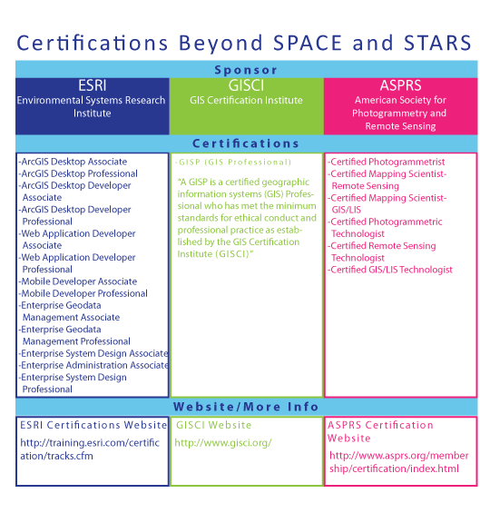
Beyond SPACE and STARS
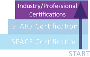
Foundations are set and you are now prepared to enter the workforce or pursue advanced academic paths. With any career students will be most valuable if they continue to refine their skills and redefine themselves. Technology will develop throughout your student's professional career, and once established we want them to take time to make sure they stay that way. Further industry, manufacturer, and academic certifications are a great way for professionals to show they have kept up with the latest industry trends and advancements.
Beyond STARS and SPACE students will find multiple tracts for advancement through professional and manufacturer certifications. The well-defined geospatial worker will consider all of these options. Each one has a distinct purpose and utilizing all of these will provide you with opportunities throughout your career.
Follow Us On:
 |
Share With Others:
|
Share With Others:


