
STARS Curriculum
Teacher Materials:
Lesson Overviews
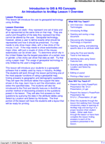
Each lesson in the teacher’s edition comes with a lesson overview page for instructors with boxes in the margins that provide quick reference to lesson goals. The overview describes in detail the skills taught in the lesson as well as additional information that may be necessary to complete the lesson. Lesson related links for further study are also supplied with each overview page.
Presentation Notes

Each student lesson comes with a PowerPoint presentation that provides an overview of the lesson including concepts, the skills covered, and the study area involved. The teacher’s manual is supplemented with detailed descriptions and commentary for each slide allowing a diverse range of instructors to lead classroom lecture.
Assessments
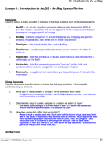
Lessons will conclude with a full page color layout of a successfully completed exercise. If questions are presented within a lesson, the teacher’s manual includes answers to those questions.

Overview
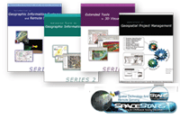
The courses delivered in the STARS curriculum series are designed to both teach and assess a student's level of competence in geospatial skills and project management. This 4 semester series of courses provides students with the skills to be an entry level geospatial technician. The introductory series covers topics from basic concepts in Project Management to GIS, GPS, and Remote Sensing. It is in this course where students learn about history of mapping, projections, coordinate systems, scale, multispectral imagery, and various other concepts that are essential to being effective in GIS/RS. The advanced series (Series Two and Three) will discuss the uses and applications of ArcGIS software and its extensions including: Spatial Analyst, 3D Analyst, Network Analyst, and ERDAS's Image Analysis extension for ArcGIS.
The fourth series is a capstone project. This project allows students to show application of geospatial skills and concepts learned in previous coursework and experiences. Upon completion this project is submitted to the STARS Certification Committee for review.
Our Philosophy is to give both the teacher and the student every thing they need to be successful. The STARS curriculum is a turn key solution that is delivered with locally customized data sets, Lesson Plans, Assessments, PowerPoints and PowerPoint Notes to help facilitate the class.
Becoming Certified
A key component and benefit of STARS is that it leads to certification. And certification is the key to showing your students have retained and are ready to enter the workforce. Students have the opportunity to gain the SPACE and STARS industry certification. Turn learn more about SPACE and STARS: Click Here!
Features in This Series
STARS Titles
Click on a title to see more information. Use the scrollbar at the bottom to see all STARS titles. To review all available Digital Quest titles visit the "Book Viewer": Click Here!
Introduction to GIS |
Introduction to GIS |
Advanced Tools in |
Extended Tools in |
Extended Tools in |
Extended Tools in |
Extended Tools in |
Application in Geospatial |

Follow Us On:
 |
Share With Others:


